Overwash EGL
When creating a project, one must choose a Standard EGL analysis or an Overwash EGL analysis. The standard situation is the most common. ASCE 7-22 and ASCE 7-16 (Supplement 1, effective December 12, 2018) specify a modification to the standard EGL analysis when the site is on an overwashed island or section of land on the ocean-side of a bay. The modification avoids the case of applying the EGL over a body of water. This modified procedure is denoted “Overwash EGL” herein.
An Overwash EGL analysis is required when there is an “Inundation Depth Point” (IDP) provided. This is a point near the shore where ASCE specifies the water depth and elevation, similar to a runup point in a Standard EGL. Clearly, a runup point does not exist in an overwash scenario.
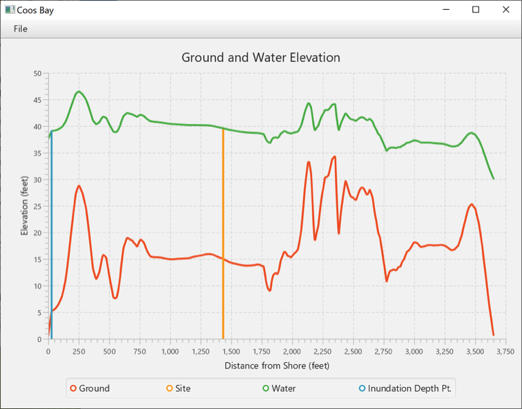
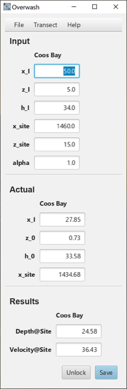
The figure below shows the main window after analysis for an overwash scenario. In the Input section, the elevation (z_I) and the water depth (h_I) of the IDP are specified, as is the approximate x-coordinate along the transect of this point (x_I). The program will search for this elevation in the vicinity of x_I, using linear interpolation if it does not correspond to a data point. The corresponding x-coordinate is reported as x_I in the section Actual.
The program sets the backside of the transect (the “inland” shore) as the last transect point with a non-negative elevation. The program has found that point to have an elevation of 0.73 feet, as shown by z_0 in Actual.
The Overwash EGL requires the water elevation (z_0 plus h_0) at the backside of the transect to be at least as high as the highest elevation along the transect. In this case, the program has determined that the water depth h_0 should be 33.58 feet to satisfy that criterion.
The site is treated the same as in a Standard EGL.
Once these values have been found, then an EGL analysis can be carried out (same procedure as a Standard EGL except the Froude number varies linearly from the value at the beginning of the transect (alpha) to 1.0 at the end of the transect.
Finally, once the water depth has been determined, it must be compared to the value at the Inundation Depth Point and shifted up or down so that the two values correspond. Any shift downward is limited such that the water depth is never allowed to be negative. In this case, the water depth was shifted down 4.18 feet. The values in the Results section for the water depth is the shifted value. The velocity profile is not modified as a result of shifting the water depth.
Most of the plots for an Overwash analysis will show two vertical lines. One locates the site and one locates the inundation depth point. If there is a gap between the inundation point and the water level, it means that shifting the water depth was limited by the elevation along the transect.